


New York City Mayor-elect Zohran Mamdani’s ambitious proposal to “put the public sector in the driver’s seat” of housing construction that promises 200,000 new affordable homes over the next decade will come up against growing flood exposure that is reshaping the city’s housing risk profile and may curtail those expansive goals.
Mamdami’s “Housing by and for New York” platform calls for tripling the amount of housing built with City capital funds and expanding programs to reach low-income households and seniors. In his platform, Mamdani pledges to “fully fund and staff” housing agencies to “increase the City’s ability to ensure housing gets preserved and built.”
But while ambitious and socially targeted housing expansion may be popular, New York City faces the increased physical risk of inundating floods and stormwater exposure that could complicate, if not outright upend, the housing agenda.
A reminder of the risk hit New York City residents last week when two men died after torrential, record-breaking rainfall sent stormwater surging into basement apartments in Brooklyn and Manhattan, triggering sudden flash floods across the New York City area.
Two recent Federal Reserve Bank of New York report outline a reality that complicates any large-scale expansion of affordable housing because of increased flood risk.
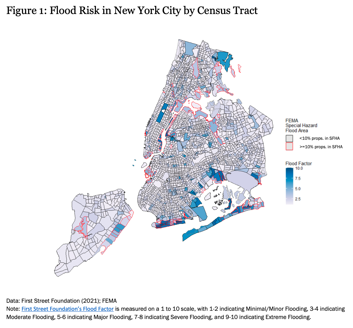
The Fed’s analysis found that over 1 million structures, home to 1.6 million households and more than 4 million people, across the tri-state area “are at a high risk of flooding.” Of those, more than 400,000 structures are located in low- to moderate-income communities.
Within New York City, the concentration is stark. “Brooklyn demonstrates the challenge,” the Fed report noted, “with thousands of properties at risk in one coastal area and thousands of others at risk relatively far inland, each situation requiring distinct investments, interventions, and responses.”
The companion report by the Fed on basement housing makes the risk more granular.
Using FEMA and First Street Foundation data, the report found that “the highest flood risk is concentrated in South and East Brooklyn, South Queens, the East Coast of Staten Island, and East Bronx,” but that “inland areas in Brooklyn and Queens with Flood Factors of 5 or above… still face major to severe risk of flooding.”
The New York City Panel on Climate Change projects the city could experience “as much as 25 percent more rainfall every year by 2100,” with the heaviest one percent of daily rainfall events increasing by 70 percent in the Northeast.
Those trends fall hardest on the very populations Mamdani seeks to house.
The Fed’s bivariate analysis found that “the tracts with the highest flood risk for low-income renters include East Bronx, East Harlem, the East Coast of Staten Island, Southern and Eastern Brooklyn, the Lower East Side of Manhattan, and Southern Queens.”
Many of these neighborhoods (dense, transit-rich, and relatively affordable) also align with areas Mamdani’s platform would likely target for redevelopment or infill.
That overlap reveals the tension between the quantity of affordable units and the quality of their siting.
Mamdani’s plan emphasizes speed, affordability, and public control but does not mention floodplain limits, drainage investment, or flood-resilient design.
As the Fed concluded, “the frequency and severity of the risk of flood loss may not be adequately captured in assistance programs informed by the 100-year floodplain.”


