


- ■ Risk: Rapid intensification's moving target
- ■ Markets: Proposal to gut California's insurance system (but keep the wildfire models)
Hurricane Erin's Wild Swings Highlight Rapid Intensification Focus
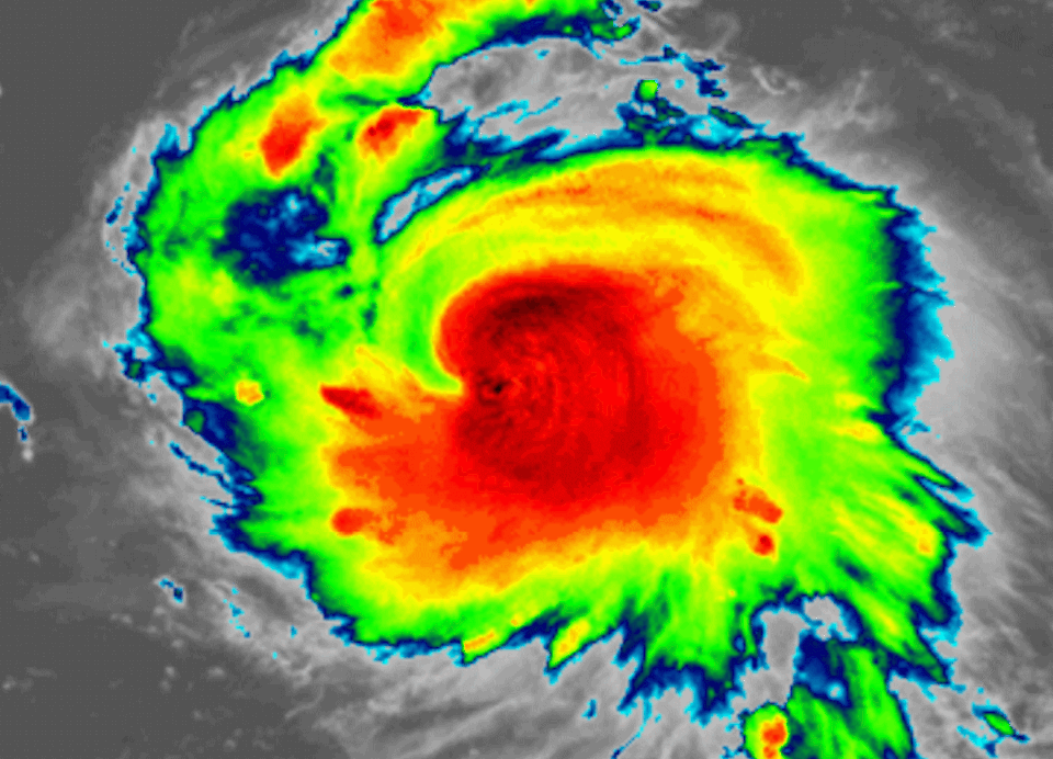
Erin's weekend swing from tropical storm to the top edge of the Saffir-Simpson scale, then back down and up again, drives home the challenges of "rapid intensification" patterns in hurricanes that researchers, risk modelers, and executives exposed to physical risk have been increasingly warning about since last hurricane season.
The first hurricane of the 2025 Atlantic season, Erin "explosively deepened and intensified" on Saturday into a Category 5 storm, according to National Hurricane Center Director Mike Brennan, before briefly weakening to a Category 4 and then regaining strength.
In case you're wondering what EXTREME rapid intensification looks like (55 mph/13 hours), behold.
— Matthew Cappucci (@MatthewCappucci) August 16, 2025
Erin is a maelstrom of meteorological mayhem as it puts on a pageant of power and elegance.
It has rapidly intensified at three time the rate needed to qualify. pic.twitter.com/oOtyge5u5U
Although Erin is expected to recurve away from the Atlantic coast, its quickly ballooning and unpredictable nature is a phenomenon that has been increasing in recent years.
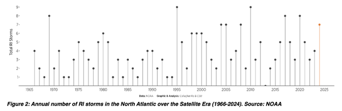
According to researchers at Colorado State University (CSU), rapid intensification occurs when hurricanes gain wind speed over the ocean at an extremely fast rate—usually more than 30 knots in a 24-hour period.
Rapid intensification has become a particular challenge in hurricane modeling and forecasting in recent years, most notably in 2024 when it was observed during the incredibly damaging Hurricanes Helene and Milton, which impacted Florida in September and October.
But rapid intensification of hurricanes has been growing for several years.
Executives Take Notice as the US Pulls Back
In the aftermath of Helene and Milton, both insurers and other industries exposed to the physical risks of rapidly intensifying storms have taken notice.
"We had two major storms hit the United States in Milton and Helene within essentially a week of each other. And I think that certainly sets the perspective on what's happening out there. We're seeing rapid intensification and we're seeing very powerful storms," said Everest Re's Juan Carlos Andrade on a 2024 investor call.
Aaron P. Jagdfeld, CEO of Generac Power Systems, said that his company was struggling to keep up with demand for standby generators as rapidly intensifying hurricanes push up orders.
"Obviously, the extreme nature of these types of events and the weather and the rapid intensification of these hurricanes—and some of the things that we're seeing in terms of the extremities of air temperature and water temperature—I think is important," he told investors last year, adding that the company would be "able to ramp quicker" to meet demand.
Just as rapid intensification has emerged as one of the most dangerous and unpredictable aspects of modern hurricanes, the federal government is cutting the research and funding needed to track and forecast these phenomena.
Last year, the Hurricane Analysis and Forecast System (HAFS) model helped meteorologists accurately forecast the rapid intensification of both Hurricanes Helene and Milton. But the scientist who worked on that model, along with some 20 others, has been fired from NOAA's Environmental Modeling Center and the Geophysical Fluid Dynamics Laboratory as part of broader cuts to the agency.
The cuts may slow or end the progress that's been made in developing weather and climate models, according to the dismissed researchers.
Adding to forecasters' concerns is the loss of crucial satellite data. The Defense Meteorological Satellite Program (DMSP), which provides specialized microwave sensors that allow scientists to effectively see through cloud tops and examine weather systems below, is being terminated. These microwave scans are crucial for accurate hurricane models, helping scientists track how storms develop and intensify.
The microwave data is especially helpful for projecting rapid-intensification events, when hurricanes make sudden, extreme gains in wind speed over short periods. DMSP accounts for as much as half of the microwave scans that help forecasters build their predictions.
"There is critical information that we can get from these satellites that we cannot get from more traditional visible or infrared satellites," Philip Klotzbach, who leads Colorado State University's annual Atlantic hurricane forecasts, told EE News, calling the announcement "certainly a surprise."
California Ballot Proposal Would Gut Current System, Push Wildfire Models and Mapping

A new ballot initiative seeks to repeal California's nearly four-decade-old property insurance regulatory system established by Proposition 103, proposing sweeping changes that further rely on standardized wildfire risk mapping and models.


